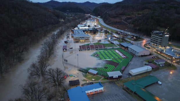
“Devastating flooding” hits small Kentucky town of Pikeville as mayor reports over 50 swift water rescues

“Significant and devastating flooding” in Pikeville, Kentucky — a small town in the eastern part of the state with a population of roughly 7,000 — has left the community submerged in water, the city’s mayor Jimmy Carter said. Dozens of swift water rescues have been conducted since a deluge of rain hit over the weekend, flooding entire neighborhoods.
Storms brought several inches of rain across eastern Kentucky over the weekend, including Pikeville. Videos show streets completely inundated with floodwaters. In one video, the steps to a church are no longer visible in the town, located in Pike County.
At least 11 weather-related deaths have been confirmed in Kentucky, Gov. Andy Beshear said Monday.
At one point late Saturday night, officials said the river level at the monitoring point in the lower Bowles Addition had reached 38 feet, prompting them to put up a flood gate. As of Monday morning, Pikeville Public Safety said the river levels had subsided enough that pond gates could be opened, but that water levels would continue to be monitored.
“The city of Pikeville has experienced significant and devastating flooding since yesterday afternoon, resulting in widespread impacts to our community,” Pikeville Mayor Jimmy Carter wrote in a statement on Sunday. “Since 3:00 PM on February 15th, the Pikeville Fire Department has responded heroically, participating in over 50 swift water rescue operations and answering more than 130 emergency calls. …Their dedication and professionalism in the face of this crisis have undoubtedly saved lives, and we owe them our deepest gratitude.”
Carter said that flooding along the Levisa Fork in Pikeville also impacted “numerous neighborhoods, including nearly every home in the Lake View subdivision near Pikeville Commons.”
“Several homes along the road in front of Pikeville High School have also suffered flood damage. Our emergency response teams continue to work tirelessly to ensure the safety of our residents and assess the full extent of the damage,” the statement said.
Aerial footage obtained by CBS News shows a large portion of Pikeville High School’s football field taken over by floodwaters from the storm. The school had at one point been used as a shelter on Saturday but had to be evacuated. On Sunday, Pikeville Independent Schools wrote on Facebook that the building “dealt with significant flooding,” and “while it could have been much worse, it has created several issues for us throughout the building.”
Justin Prater
“We currently have a large and outstanding restoration team on site that has been working most of the afternoon and will work into the evening,” the district said on Facebook. “They have assured us and quickly proven that they will be highly efficient, while also being very clear that they are going to assure our facility is safe for our students and staff. Please be patient with us, as this will be an efficient but not immediate process. … We will develop a plan moving forward to continue to provide a high level education to every student, even through some difficult times.”
Gov. Beshear warned residents on Monday that the state is “still experiencing widespread impacts from the severe weather.”
“We need everyone to be aware that conditions are dangerous, and folks need to stay off the roads in areas with high water,” he wrote on social media.
Dangerous conditions aren’t over yet for Pikeville and surrounding areas, with the National Weather Service in Jackson, Kentucky issuing a winter storm watch for the region that will remain in effect from Tuesday evening through Thursday morning.
The warning says that the area could see between 2 and 5 inches of snow. The impacts are part of a snow, sleet and ice-filled winter storm that’s forecast to develop over the Central Plains on Tuesday and track to the South and Southeast before heading to the Mid-Atlantic by the end of the week.


